Understanding how something walks is a fundamental question in vertebrate biology. If you want to study the biomechanics of a living animal, such as a human, you simply get them to walk on a pressure treadmill and this captures the pattern of basal (plantar) foot pressure. With larger animals it is a little trickier and there is a reason why we only have a small number of pressure records for elephants since it is not that easy to get them to walk on a treadmill! For an extinct animal, such as a mammoth or a dinosaur, it is impossible. In such cases we use fossil footprints, substituting footprint depth for pressure, but unfortunately research has shown that this does not work as well as one might hope. Something called ground penetrating radar (GPR) provides an alternative.
Popular TV shows such as Time Team and The Curse of Oak Island have transformed public understanding of geophysics; tools by which archaeologists and geologists image the hidden subsurface. As one over enthusiastic presenter once said ‘it allows us to x-ray the ground, like Superman looking through the soil to see what is buried below!’ Ground penetrating radar was first developed in the early 20th Century but was not really developed until the Vietnam War when it was used to image subsurface bunkers and it is now used by engineers to view cracks in railway tracks and girders. It is essentially an electromagnetic transmitter/receiver, a mobile phone on steroids if you like, and its signal penetrates the ground with varying speed, determined by the properties of that ground. The signal is reflected back to the surface by boundaries that show marked changes in physical properties, thereby revealing the shape of those boundaries. It is generally a tool for imaging big stuff (think walls) in the archaeologist’s toolkit.
Our research team have been working for several years at White Sands National Monument (WHSA) in New Mexico which contains the largest assemblage of vertebrate Ice Age tracks, probably in the world. These tracks are preserved on a dried lake bed (Alkali Flat), but they are difficult to see which is why colloquially they are referred to as ghost tracks. Seeing them is quite important not only so that we can track and map the interaction of human hunters with extinct Ice Age fauna, but also for their conservation. Much of Alkali Flat is in co-use with the White Sands Missile Range, famous as the birth place of the American space programme, of the first nuclear blast at Trinity and Regan’s infamous Star Wars initiative. In places missile debris litters the ground and being able to map conservation priorities is important especially since the true significance of the track assemblage at WHSA became known only in 2018 with the recognition of human tracks.
 Images of Ice Age human footprints at White Sands National Monument (New Mexico), also showing the ground penetrating radar and the foam mats used in the survey [Author supplied].
The research team have had some success in using geophysics to map large animal tracks, but to our surprise we found that high-resolution ground penetrating radar gives fantastic results. Now when we say high-resolution we are spacing our survey lines at around 10 cm or so; typical survey line spacing would normally be measured in metres. We place foam jigsaw mats out on the desert floor, the sort of things you get at play school or in your home gym, and move the radar across this surface line by line.
Not only can we image large mammoth and giant ground sloth tracks but we can also image to those of human hunters that co-existed with these animals. The electrical properties between the track fill and the printed ground are subtle but sufficient for the tracks to stand out. There are many advantages. Not only does it allow us to prospect for tracks, but it allows us to image buried tracks and deduced sequence of superposition.
 GPR imaging of mammoth, giant ground sloth and human tracks at White Sands National Monument [Author supplied].
We also noticed something cool beneath the mammoth tracks. Below the base of the tracks we consistently saw a radar feature, hook-like in cross-section, we believe is caused by compressed sediment. Comparing these structures to modern plantar pressure records, kindly donated to us by researchers at the Royal Veterinary College in London and Monash University, we see a tentative match. It makes sense since that is where the plantar pressure would have been greatest beneath a mammoth’s foot and the sediment most compressed. The radar signal appears to be picking this out. In fact we can get a similar pressure record off the human and giant ground sloth tracks. We still have work to do but it appears as if the radar signal is able to give us a plantar pressure record from an extinct animal independent of the footprint itself. In terms of studying the biomechanics of Ice Age giants this is revolutionary especially for animals like the giant ground sloth which had a peculiar gait, walking on the outside of its feet.
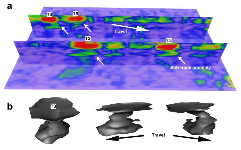 Subsurface anomalies below mammoth tracks. These are caused of compression below the footprint caused by the plantar pressure. The spaceship like sculptures shows this; the top disc or surface is the actual footprint and the structure below the anomaly. They resemble the pressure patterns found for modern elephants [Author supplied].
At this point we firmly move to the near-future, because as with all new ideas there is validation work to be done. But assuming this all comes good and crucially the technique works outside the specific gypsum rich sediments of White Sands as we believe it will, then the implications are significant for those who study biomechanics. For example, we might be able to use it map footprints elsewhere especially where digging could be disruptive at such famous footprint sites like that at Laetoli in Tanzania where the oldest human footprints in the world are to be found. Or alternatively search for buried footprints around shallow or mass graves. But the big goal is to be able to obtain a plantar pressure record from beneath a dinosaur’s foot. We are not quite there yet, but given the right geological circumstances it is we believe possible and with funding we hope to try soon.
This work was carried out by: Tommy Urban and Sturt Manning of Cornell University, Matthew Bennett, Matteo Belvedere and Sally Reynolds from Bournemouth University and David Bustos, Daniel Odess and Vincent Santucci from the National Park Service in the USA.